
Episode 1
The Creation of the Map

“Today the world has been discovered, that is to say, broadly speaking, it is known everywhere. Bold sketches are no longer enough. Now the mosaic between the contours must be filled in. The explorer takes the place of the researcher, the instrument takes the place of the eye, the surveyor and the statistician take the place of the storyteller.”
Wilhelm Rickmer-Rickmers, 1930
Introduction
The years leading up to World War I and the interwar period were a time marked by great expeditions that included the highest mountains that had yet to be explored. The first expeditions were primarily motivated by the pursuit of scientific knowledge, and driven by nationalist and colonial concerns. Gradually, sporting achievements became more important: the first ascent of previously unclimbed peaks thus became one of the new objectives of these expeditions.
In the field of science, the search for the unknown and unexplored, the ethnographic observations, and the desire to describe mountain ecosystems were the main motivations. During the National Socialist era in Germany and Austria, propaganda and mountaineering were combined in large-scale media campaigns that were well received by the public.
In South America, until the late 1920s, most of the high Andean peaks remained unclimbed and large parts of the region had not yet been explored or mapped, making South America a major expedition area. *
* Similar to the development of mountaineering, the beginnings of Andeanism are also found in the scientific exploration of the mountain range. Initially it was mainly European scientists, naturalists, botanists, cartographers and geologists who began to explore the Andes region with a scientific interest in the 19th century.

The Cordillera and the Expeditionaries
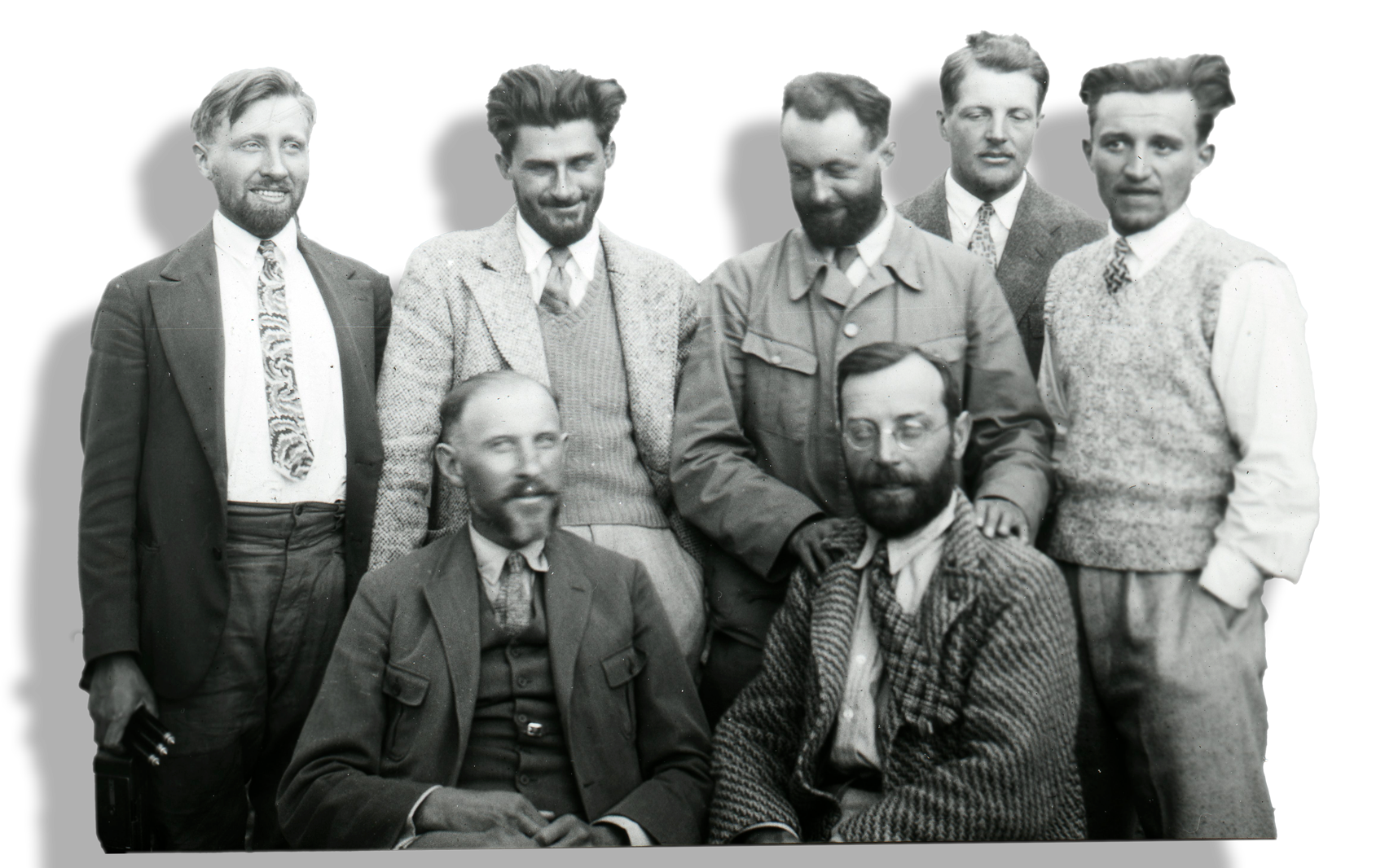
At the beginning of April 1939, an expedition team of six men belonging to the Austrian-German Alpine Club, scientists, and mountain sportsmen, divided between two ships, left Germany for Peru. After more than a month at sea, they arrived in the port of Callao on 6 May 1939.
The expedition was led by Hans Kinzl, who had already participated in the Andean expeditions of 1932 and 1936. Professor Kinzl was one of the most important representatives of glacier research of his time. The expedition focused on the southern part of the Cordillera Blanca. The aim was to complete the first scientifically detailed map of the area.
By May 20, all the necessary preparations to start the expedition were being taken care of: base camp in Yungay was set up, government offices were visited, and porters and pack animals were hired and organized. The expedition members make several exploratory trips into the area in different groups. On the one hand, they pursue mountaineering objectives and, on the other, they continue the cartographic work begun in 1932.
The Expedition of 1939

It was the desire to map the entire southern Cordillera Blanca and to make it as accessible as possible for mountaineering, that led to the Alpine Club’s third trip to the Peruvian Andes in 1939. A region covering some 6000 square kilometers, situated at an average level of about 4000 m.a.s.l., whose highest peaks were 6400 m and whose lowest valleys were 2500
m.a.s.l. *
m.a.s.l. *
In the first days of August 1939, the fieldwork in the Cordillera Blanca was completed. Only a few weeks separated them from the planned date for the journey home. A time that was to be used for a trip to the glaciers of central Peru came to a bitter end when Hans Schweizer, Siegfried Rohrer and the German-Swiss guest Jakob Diener were killed in avalanches. Almost at the same time, they were surprised by the outbreak of the war in Europe, which cut off their way home across the Atlantic Ocean.
* During the 1932, 1936 and 1939/40 expeditions in the Cordillera Blanca, the expedition members climbed for the first time 12 of the 18 six-thousand-metre peaks of the largest and highest glaciers in the tropics. In the 1932 expedition, Artesonraju (6025 m.a.s.l.), Huandoy (6395 m.a.s.l.), Huascarán Sur (6746 m.a.s.l.), Chopicalqui (6345 m.a.s.l.) and Copa (6188 m.a.s.l.) were climbed for the first time. In 1936, the summits of Quitaraju (6036 m.a.s.l.) and Pucajirca Sur (6039 m.a.s.l.) followed. In 1939 the peaks of Hualcán (6122 m.a.s.l.), Palcaraju (6274 m.a.s.l.), Tocllaraju (6034 m.a.s.l.), Chinchey and Ranrapalca (6162 m.a.s.l.) were reached.


«Meanwhile, the outbreak of war had put us survivors in a difficult situation. Going home was and is out of the question; indeed, the recruiters, to which we all belong, are forbidden to attempt it, as it would almost certainly be doomed to failure. Our means are almost exhausted. But with the sale of the remaining food and equipment we have raised enough to live on for the time being.»
Hans Kinzl, Octubre 1939
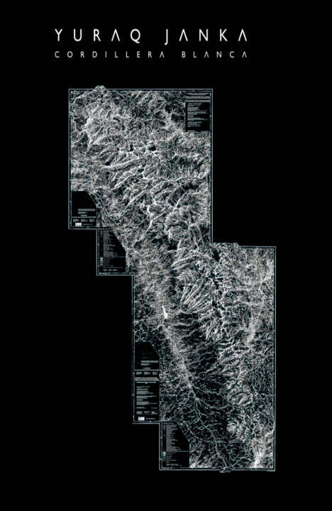
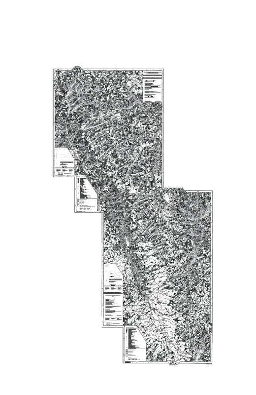
The Map
Returning home in early 1941 became the most significant challenge for the expeditionists. Fearing arrest by Allied ships before reaching Germany, they were forced to take a detour through Japan and Siberia. Carrying only hand luggage, they left almost all the expedition’s equipment, instruments and scientific collections in Lima, which were subsequently confiscated after Peru’s entry into the war.
Fortunately, they had managed to save paper printouts of the measurements, a large part of the photographic images and the field books. Thus, despite all the losses, they still had a sufficient basis for the new map. It was only towards the end of the Second World War that the map of the southern part of the Cordillera Blanca was printed in an already disbanded office of maps, which had been set up by the participants during the war.
The culmination of the creation of the map after the 1939 expedition represents a turning point in the recent history of the Cordillera Blanca. The beginning of a new chapter in its history. The map allowed us to uncover previously unknown facets, but also ushered in an era marked by constant monitoring and human intervention in its environments, in an attempt to contain them and adapt them to our own interests.
«The new map of the Cordillera Blanca South covers a high mountain landscape of almost 5,700 square kilometres. Most of it was new mapped territory. But that is not the significance of our map. Much more important to us is the fact that the map is the first accurate representation of glaciation in this section of the Andes and was for a long time. For the first time, it provided a reasonably reliable basis for the study of current glacier conditions and therefore also represents a document whose value for the assessment of future glacier and climate fluctuations can only grow with the passage of time.»
Hans Kinzl

The Cordillera Blanca AR app combines 3D geographic data and archival footage and allows users to participate in a one-of-a-kind expedition: an interactive exploration of the changing geography of the Cordillera Blanca.